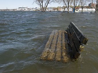
 (Host) Lake Champlain is finally receding from its record levels. But predicting the next big flood may be more difficult because of budget problems in Washington. VPR’s John Dillon reports:
(Dillon) Greg Hanson is a hydrologist at the National Weather Service in Burlington. He and his colleagues have been busy lately forecasting floods in the Lake Champlain basin. And he watches the lake by tracking a gauge that measures water levels at Rouse’s Point, New York, just before the big lake flows into the Richelieu River in Quebec.
Hanson says the gauge at Rouse’s Point and another in Whitehall, New York, in the southern part of the lake are essential for making accurate forecasts to protect people and property. Gauges in rivers provide similar data. Hanson is worried about a federal budget shortfall that could shut down eight of the instruments in Vermont and 18 in New York.
(Hanson) "It would be possible for us to issue a forecast without knowing the observed data, but it’s really, it’s like using a road map without knowing where you are to begin with. If we don’t have the observed data to know what our start off point is, the forecast wouldn’t be of much value."
(Dillon) The stream and lake gauges are operated by the U.S. Geological Survey. The survey posts the information online, so the public can see real time water levels as well as historic records stretching back decades.
The data is free for the viewing. But people checking out the web site recently saw an unusual appeal from the federal agency. The USGS asked the public to help pay for the gauges. Keith Robinson is director of the Vermont-New Hampshire USGS science center.
(Robinson) "We are hoping to work this summer with a lot of the stakeholders that use this information, whether it’s dam operators, or other agencies or even local town groups, to see if we can kind of go out and kind of pass the hat to see if people can help support our next fiscal year."
(Dillon) The gauges in Vermont cost about $15,000 a year to operate, with USGS getting help from local or state agencies to help cover the cost. Some of that local match has come from congressional earmarks secured by Senator Patrick Leahy. But the budget is being squeezed in Washington and earmarks are no longer easy to obtain.
The gauges provide valuable information – and not just for predicting floods. The Vermont Department of Environmental Conservation tracks the stream flows to determine how much phosphorus pollution reaches the lake. Justin Johnson is deputy commissioner.
(Johnson) "It’s also a significant data set that goes back many years, and we’d like to keep that going. It gives us sort of our eyes into what’s actually happening in terms of the phosphorus going into Lake Champlain."
(Dillon) Pete Diminico of the New Haven River Watch program says volunteers recently used a gauge near Middlebury to help figure out where to build a ramp so handicapped anglers could reach the river.
(Diminico) "So it’s used by everybody. It’s not just used by one source or two. It’s very valuable."
(Dillon) The funding squeeze has affected other USGS data collection efforts around the country. But as floods sweep the nation, advocates hope Congress will see the value of knowing how high the rivers will rise.
For VPR News, I’m John Dillon.
USGS Real-Time Water Data for Vermont