 (HOST)
Tropical Storm Irene brought an interruption to the hiking season. Even
now, some of the side trails haven’t reopened and the Long Trail and
Appalachian Trail between Route 103 and Route 4 is still closed, but
people are already returning to the woods. And commentator Vic Henningsen knows
why. He visited the trail this summer and brought back a snapshot of why
hikers are so eager to get back on the trail.
(HENNINGSEN)
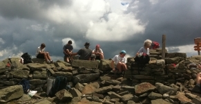
I’m on the summit of New Hampshire’s Mount Moosilauke attempting to
admire the view. The Green Mountains lie west but the real action is
north and east, where Moosilauke provides a front row seat for the show
that is the White Mountain National Forest.
Or it will when the
clouds lift. Right now we’re getting only intermittent glimpses of
distant ridgelines. Still, the half-dozen or so Appalachian Trail
through-hikers eating lunch here seem content to wait for the curtain to
rise. They’ve been thinking about it since early spring.
 On Moosilauke northbound AT hikers first see the full extent of the Whites.
They’ve looked at New Hampshire from summits and ledges in Vermont for
over a hundred miles, but couldn’t see the Whites because Moosilauke –
over 4800 feet high – bars the way. The trail itself is cunningly
engineered so northbound hikers can’t see what’s ahead until they
actually step onto the summit. Then it all opens out with, at times,
impressive impact. I remember, years ago, seeing a weary northbounder
trudge to the summit, look up and, overcome by the view he’d been
anticipating for months, fall over backwards.
Here, southbounders bid farewell to the high drama of the northern peaks. With the
exception of Killington, they won’t get above 4000′ again until
Virginia.
For northbounders it’s a more complicated moment.
They’ve come roughly two-thirds of the total distance but, it’s said,
they’ve only done half the work.
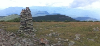
As
the clouds blow out, we can see a good bit of the rest of it. One by
one the Whites emerge from the mist, from the Kinsmans immediately
north; over to the Franconia Ridge; all the way to Guyot and the Bonds.
Only the upper slopes of the Presidential Range remain hidden,
mysterious.
For a moment, the mood on the summit tightens.
Conversation stops. Maps appear. Fingers trace the route. Anxious eyes
survey gear and food. This is it.
Then, as the sun shines down, we all relax. This is it. This is why we’re here.
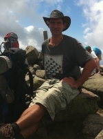
Through-hiker Dan Smith – trail name "Indy" – sums it up:
(Smith)
Everyone’s been talking about the White Mountains since even in
Georgia… They’re supposed to be the roughest part, so I’ve been
thinking about it for a pretty long time.
He’s a bit nervous:
(Smith) They’re just a lot steeper mountains than I’m used to.
But
he’s got his act together: he’s been hiking since March 1st; his gear’s
down to thirty pounds; and he’s looking forward to this section’s Holy
Grail:
(Smith] Definitely Mount Washington.
But he’s in no hurry.
(Smith) I’d like to go a lot slower than I have been in the past and sort of soak it all in.
As
the afternoon wears on, Smith and his companions – a couple of college
students, a middle-aged vet and her husband – linger, unwilling to let
the moment go. They can see the future. And it looks good.
(Smith) Everybody loves the White Mountains.